
The 10 best photo spots in Edinburgh, and when the light is right
Calton Hill at sunset, Dean Village, the Forth Bridge after dark and the causeway to Cramond Island you can only walk at low tide: where to stand and when.
Edinburgh is built on volcanoes, and that's what makes it easy to photograph: wherever you stand there's a hill to look down from or a crag to look up at. The classic views really are the best ones. What we can add is the exact spot, the week the sun lines up, and the one place on this list you can only reach when the tide is out.
For every spot below we went through the most interesting public photos on Flickr taken nearby, and counted each photographer once per day, so one person's hundred frames from a single afternoon count as one visit. That shows when people really go. The camera data of a dozen of the best photos, each by a different photographer, shows how they shot it, and the sun bearings come from the same calculations as the sun and moon tool on our hotspot maps.
A note on the light. Edinburgh sits at 56° north, further north than Moscow. In December the sun rises after half past eight and sets before four, low in the south all day, which is flattering for stone and means you can shoot the sunset and still be home for tea. In June it sets after ten in the northwest, and it never gets properly dark. Then there's August, when the Festival and the Fringe double the city's population: it's the busiest month at six of the ten spots below, and November is the quietest across the guide.
1. Calton Hill and the Dugald Stewart Monument
Calton Hill, at the east end of Princes Street

This is the picture of Edinburgh, and it takes ten minutes to get to from Waverley station. Climb the steps from Regent Road and walk to the Dugald Stewart Monument, the round temple of columns on the southwest corner of the hill. Frame the city through or beside it: the clock tower of the Balmoral Hotel, the spires of the Old Town and the castle on its rock, all in one line.
The view faces west, so it's a sunset spot, and in winter the sun goes down right behind the castle. From the monument the castle lies at a bearing of about 236°, and the sun sets on that line around November 17 and again around January 27, give or take a few days. Those are short days, with sunset around four o'clock, so you can be there and still be in a pub by five.
Turn around for the rest of the hill: the twelve columns of the unfinished National Monument, abandoned when the money ran out in 1829, and the Nelson Monument, which you can climb for a higher view. On April 30 the hill hosts the Beltane Fire Festival, a night of drums and fire that's one of the city's best photo events.
Most people bring a wide lens here, and most of the photos in our sample with camera data were shot wide, at f/8. That fits the whole skyline in, but it makes the castle small. For the winter sunset behind it, bring something longer as well.
- Best light
- Sunset; the sun sets behind the castle around November 17 and January 27
- Busiest months
- July and August (quietest: March)
- Typical shot
- 24mm, f/8, 1/33s, ISO 100
- Getting there
- Steps from Regent Road, 10 minutes from Waverley station
2. Edinburgh Castle from below
Princes Street Gardens, the Grassmarket and the Vennel

The castle is better photographed from outside than from inside, and there are two sides to it. From Princes Street Gardens you look up at the north face, where the rock drops straight down to the trees; the Ross Fountain, painted in gold and teal, makes a foreground at the west end of the gardens. The light reaches this side only on summer evenings, so in winter it's a silhouette shot.
The south side is the one in the guidebooks. Go to the Grassmarket and climb the Vennel, the stepped lane at its west end: from the top of the steps, the castle fills the space between the old houses, with the Flodden Wall alongside. It faces north, so overcast days are kind to it. Victoria Street, the curving lane of painted shopfronts that leads down into the Grassmarket, is two minutes away and best early, before the shops open and the crowds arrive.
The One O'Clock Gun fires from the castle every day except Sundays, and in August the Military Tattoo fills the esplanade with floodlights and pipers. August is the castle's busiest month by a distance, with 17% of the year's visits in our sample, so if you're here for the Festival, shoot early. Long lenses do well from below: four of the ten photos with camera data were telephoto shots, picking out the walls and the batteries against the sky.

- Best light
- Early morning from the Vennel; summer evenings from the gardens
- Busiest months
- June and August (quietest: March)
- Typical shot
- 67mm, f/6.3, 1/125s, ISO 100
- Getting there
- The Grassmarket is 10 minutes from Waverley; the gardens are next to it
3. Dean Village
On the Water of Leith, below the Dean Bridge

Ten minutes' walk from the West End, the city drops into a gorge and you're in a mill village. Dean Village grew up around water mills on the Water of Leith, and the river still runs through the middle of it. The shot most people want is from the small bridge at the bottom of Bell's Brae: the river, the old mill buildings and Well Court, the red sandstone courtyard with a clock tower built in the 1880s as housing for workers.
Down in the gorge, direct sun is brief and patchy, which suits it: bright overcast days and the hour after rain give the stone its color. People live in every one of these houses, so keep to the lanes and the riverside path, and keep the noise down early in the morning. August, September and October are the busiest months here, almost equally; the trees along the river turn in October, and it's the month to choose if you can.
Follow the Water of Leith Walkway downstream, under Thomas Telford's Dean Bridge, and in fifteen minutes you're at St Bernard's Well, a little Roman temple on the riverbank, and then the cafés of Stockbridge.
- Best light
- Bright overcast, or just after rain
- Busiest months
- August and September (quietest: January)
- Getting there
- Bell's Brae, off Queensferry Street, 10 minutes from the West End
4. Arthur's Seat
Holyrood Park

Arthur's Seat is the main peak of an extinct volcano in the middle of the city, 251 meters high, and the walk up from Holyrood takes about forty minutes. From the top you see all of Edinburgh at once: the castle and the Old Town to the west, Leith and the Firth of Forth to the north, and the Pentland Hills to the south.
Sunrise is popular here, but the city is at its best at sunset, laid out below you with the light behind it. From the summit the castle lies at a bearing of about 282°, so around April 6 and September 8 the sun goes down on the line of the castle. It's a long way off, 2.4 kilometers, so bring a telephoto as well as a wide lens. The median focal length in our sample was 50mm, a sign that people were already cropping in on the city. January, surprisingly, is the third busiest month for visits here, behind May and August; plenty of people in Edinburgh start the year with the climb.
The summit is rocky, crowded at sunset in summer and windy at any time of year; a tripod needs weighting down. Take a headlamp for the walk back. The Radical Road path under Salisbury Crags was closed after a rockfall in 2018, so check before planning a route along it.
- Best light
- Sunset; the sun sets on the line of the castle around April 6 and September 8
- Busiest months
- May and August (quietest: February)
- Typical shot
- 50mm, f/6.3, 1/200s, ISO 100
- Bring
- A telephoto, a headlamp and a warm layer
5. St Anthony's Chapel
Above St Margaret's Loch, Holyrood Park

If Arthur's Seat is too far, stop halfway. The ruined walls of St Anthony's Chapel, from the fifteenth century, stand on a rocky shoulder of the hill above St Margaret's Loch, ten minutes from the road. It's the most romantic ruin in the city, and the gable with its empty window is a perfect frame for the sky.
There are two classic shots. From the loch below, the chapel stands on the skyline above the water and the swans. From beside the chapel, the ruin is in the foreground and the city spreads out behind it to the west. From there the castle is at a bearing of about 265°, and the sun sets behind it around March 13 and October 3. Four of the ten photos in our sample with camera data used a telephoto, which suits the view of the ruin from across the loch, and the median ISO was 400: on this exposed shoulder of the hill, the wind makes a tripod hard work.
- Best light
- Sunset; the sun sets behind the castle around March 13 and October 3
- Busiest months
- April and August (quietest: November)
- Typical shot
- 48mm, f/7.9, 1/158s, ISO 400
- Getting there
- From the car park on Queen's Drive by St Margaret's Loch
6. Royal Botanic Garden
Inverleith, north of the New Town

The garden was founded in 1670 and moved to Inverleith in the 1820s, and its 70 acres are free to walk around. Most visitors come for the plants, but photographers should come for one view: from the lawn by Inverleith House at the top of the garden, the whole skyline of the Old Town, the castle and the spires lines up across the trees, with the garden's autumn colors in front.
The Victorian glasshouses are the other subject, though a long restoration project means some of them are closed; check what's open before you go. The data says photographers here are mostly after flowers and birds: seven of the eleven photos in our sample with camera data were taken with a telephoto, and the median focal length was 105mm. It also says they miss the best month. Visits are spread evenly from spring to September, but October, when the maples and the beech trees turn, is the quietest month of the year.
- Best light
- Late afternoon in October, for the autumn color and low sun on the skyline
- Busiest months
- June and August (quietest: October)
- Typical shot
- 105mm, f/5.6, 1/250s, ISO 125
- Getting there
- The East Gate on Inverleith Row; entry to the garden is free
7. The Shore, Leith
Where the Water of Leith meets the docks

Leith was Edinburgh's port for centuries, and The Shore is where the Water of Leith runs out between old warehouses and merchants' houses into the docks. Today the warehouses are restaurants and bars, and on a still evening the whole row is reflected in the river. It's the best blue-hour spot in the city that doesn't involve a climb.
Stand on the bridge at the bottom of Bernard Street, or on the swing bridge further down, and wait for the lights to come on. Three of the eleven photos in our sample with an exposure time were long exposures of a quarter of a second or more, the most of any spot in this guide, and that's the trick here: a few seconds smooths the river into a mirror. The tram has run to Leith since 2023, so it's an easy trip from the center.


Sunset and night at The Shore.
- Best light
- Calm evenings, in the blue hour after sunset
- Busiest months
- August and September (quietest: February)
- Typical shot
- 27mm, f/5.6, 1/30s, ISO 100
- Getting there
- Tram to The Shore stop
8. Newhaven Harbour lighthouse
Newhaven, on the Firth of Forth

Newhaven was a fishing village, and its little harbour still has a lighthouse at the end of the west breakwater. The harbour faces north across the Firth of Forth to Fife, so the light comes from the side at both ends of the day, and in summer the sun sets over the water to the northwest.
Here's the detail most people miss. The Forth Bridge is twelve kilometers up the firth from the harbour, at a bearing of about 280°, and the sun sets behind it around April 3 and September 12. On a clear evening, with a long lens from the breakwater, you get the bridge's three cantilevers as a black outline in the sun. Nobody in our sample tried it: not one of the twelve photos with camera data used a telephoto, and the median aperture of f/2.4 says most were taken on phones. June and July are the busiest months here, when the sun goes down late and far to the northwest.
- Best light
- Sunset; the sun sets behind the Forth Bridge around April 3 and September 12
- Busiest months
- June and July (quietest: November)
- Typical shot
- 33mm, f/2.4, 1/2762s, ISO 125
- Getting there
- Tram to Newhaven, the end of the line
9. The Cramond Island causeway
Cramond, on the Firth of Forth

Cramond Island is a tidal island, joined to the shore by a causeway of about a mile that you can only walk at low tide. Along one side runs a line of concrete pylons, built in the Second World War to stop boats from passing, and that line of teeth disappearing toward the island is one of the great leading lines in Scotland. On the island there are the ruins of gun batteries and a view back to the city.
The tide is the whole plan. The coastguard advises crossing only in the two hours either side of low water, and the safe times are posted on a sign at the start of the causeway; you can also text CRAMOND to 81400 to get them. The tide comes in fast across the sands on both sides, and lifeboat crews rescue people from the island every year. Keep your eye on the clock rather than the camera. August brings a fifth of the year's visits in our sample, so on a summer weekend with a midday low tide, expect company on the causeway.
You don't have to cross at all. From the shore at Cramond, as the tide comes in around the pylons, a long exposure turns the water smooth and leaves the concrete standing in mist.
- Best light
- Low sun at low tide, morning or evening
- Busiest months
- June and August (quietest: September)
- Bring
- The day's safe crossing times, and a watch
10. The Forth Bridge from South Queensferry
South Queensferry, 10 miles west of the center
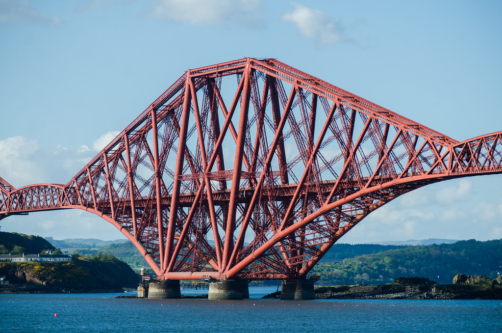
The Forth Bridge opened in 1890, a railway bridge of three huge steel cantilevers about two and a half kilometers long, and it's still the most photogenic bridge in Britain. Since 2015 it's been a World Heritage Site. Two newer road bridges, the Forth Road Bridge of 1964 and the Queensferry Crossing of 2017, run alongside it, so from the right spot you get three centuries of bridges in one frame.
South Queensferry is the best base. From the pier by the Hawes Inn you're right under the south end of the bridge, looking up into the steelwork; walk east along the shore path for a side-on view of all three cantilevers. The bridge is floodlit at night, and the red steel against the last of the blue sky is the shot. From the pier, bring the widest lens you own: it's the only way to fit a two-and-a-half-kilometer bridge into the frame from under one end of it. Trains from Waverley to Dalmeny take about fifteen minutes, and it's a short walk down from the station.

- Best light
- Blue hour, 20 to 40 minutes after sunset
- Busiest months
- May and July (quietest: January)
- Getting there
- Train to Dalmeny, then 10 minutes downhill
If you have more time
The Royal Mile is best before nine in the morning, when the closes (the narrow alleys off the street) are empty and you can look down them to the Firth. In December the Christmas market fills East Princes Street Gardens around the Scott Monument, with a big wheel lit up beside the Gothic spire. And for a wilder view of the castle, climb Blackford Hill to the south: you see it with the whole Old Town ridge, and far fewer people.

How we worked it out
For each spot we took up to 500 of the most interesting public Flickr photos taken nearby, counted one visit per photographer per day, and added them up by month. The typical settings are the medians from the camera data of up to twelve of those photos, each by a different photographer. Sun bearings were calculated for each viewpoint and are good to a few days either way; hills and buildings on the horizon can shift the exact moment. Every spot has its own page on ShotHotspot with all its photos, a map and the sun and moon tool, so you can check the light for the day you're going.


